Route 66: The Mother Road from Chicago to Santa Monica
A complete guide to America's most legendary highway: historic map, eight states crossed, 7/14/21-day itineraries, timeline, iconic attractions, 18 documented anecdotes, and links to state tourism offices and the National Park Service.
Route 66 (U.S. Highway 66) is one of the most celebrated arteries
on the American road network. Established on November 11, 1926, it linked
Chicago (Illinois) to Santa Monica (California) across
roughly 2,448 miles, eight states, and three time zones.
Nicknamed the Mother Road by John Steinbeck, it fed the
Main Streets of Midwestern towns, Great Plains communities, and Southwest
outposts before reaching the Pacific.
Fully paved by 1938, it became the highway of the
Dust Bowl exodus, then the symbol of the 1950s-1960s American road trip.
The Interstate system gradually replaced it; on
June 27, 1985, it was removed from the federal U.S. Highway System.
Since then, a revival led by local associations (including
Angel Delgadillo in Seligman in 1987) has turned the Mother Road into
a major heritage and tourism route.
This guide is for travelers planning a trip or anyone curious about the road's history.
It draws on the National Park Service, the Federal Highway Administration, the Library
of Congress, and the tourism offices of all eight states along the corridor.
Key takeaway: Route 66 was decommissioned in 1985 and no longer appears on current federal highway signs. According to the NPS, about 85% of the historic alignment remains drivable via sections marked "Historic Route 66." Check which segments are open before you leave.
The eight states crossed
1 Illinois2 Missouri3 Kansas4 Oklahoma5 Texas6 New Mexico7 Arizona8 California
Mapping
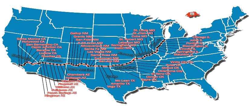
2. Route map
The historic east-to-west alignment from Illinois to the Pacific Ocean. Alignments varied over the decades; consult NPS maps for each state.
General alignment Chicago to Missouri → Kansas → Oklahoma → Texas → New Mexico → Arizona → Santa Monica. Source: NPS / FHWA alignments.Planning
3. Official state resources
Each state tourism office publishes maps, alignments, and local events. The NPS centralizes historical documentation for the Route 66 corridor.
Established on November 11, 1926 as part of the new federal
U.S. Highway System, Route 66 connected the agricultural Midwest to the Pacific Coast.
Unlike the straight Interstates that followed, it ran through downtowns, fueling
motels, gas stations, and mom-and-pop shops along the way. Hence its nickname,
the "Main Street of America."
Fully paved by 1938, it became the first major transcontinental
highway paved end to end. During the Great Depression and the
Dust Bowl, thousands of families took it west toward California.
After World War II, it embodied prosperous postwar America: road trips, neon diners,
and themed motels.
The Interstate Highway Act (1956) launched the network that would
gradually bypass Route 66. On June 27, 1985, the American Association
of State Highway Officials officially removed it from the federal system. Bypassed
towns declined, but a revival began in
1987 when barber Angel Delgadillo founded the
Historic Route 66 Association of Arizona in Seligman.
Today the corridor is protected and promoted as a heritage route. The 2026 centennial
mobilizes associations, states, and Congress through the Route 66 Centennial Commission.
Timeline
8. Timeline
Major dates on the Mother Road, from creation to centennial.
Nov. 11, 1926
Official creation
U.S. Route 66 is added to the federal highway network, linking Chicago to Los Angeles (later Santa Monica).
1938
Fully paved
Route 66 becomes the first major transcontinental highway paved from one end to the other.
1939
Steinbeck and the "Mother Road"
John Steinbeck publishes The Grapes of Wrath and names the route "the Mother Road," immortalizing the Dust Bowl exodus.
1946
Bobby Troup's song
Bobby Troup writes "(Get Your Kicks on) Route 66," popularized the same year by the Nat King Cole Trio.
1956
Interstate Highway Act
Federal interstate legislation launches the highway network that would gradually replace Route 66.
1960-1964
TV series "Route 66"
Aired on CBS, the show anchored the road in global pop culture, even though filming covered other states beyond the historic alignment.
June 27, 1985
Official decommissioning
Route 66 is removed from the U.S. Highway System, replaced by Interstates 55, 44, 40, 15, and 10 along various segments.
1987
Revival in Seligman
Angel Delgadillo founds the Historic Route 66 Association of Arizona. Nostalgia tourism and preservation take off again.
2006
Pixar's "Cars"
The film draws on forgotten Route 66 towns. Radiator Springs mirrors the decline of communities bypassed by Interstates.
2026
Centennial
Route 66 turns 100. Congress created a centennial commission (route66centennial.org) to coordinate commemorations and events.
"If you ever plan to motor west, get your kicks on Route 66!"
Bobby Troup, "(Get Your Kicks on) Route 66," 1946 (popularized by Nat King Cole)
Iconic sites
9. Must-see attractions
The journey starts in Chicago, with live music, museums, and architectural
landmarks (Willis Tower, Wrigley Building). In Missouri, the
Gateway Arch in St. Louis marks the gateway to the West. Oklahoma and
Texas serve up roadside kitsch: the Blue Whale in Catoosa, the
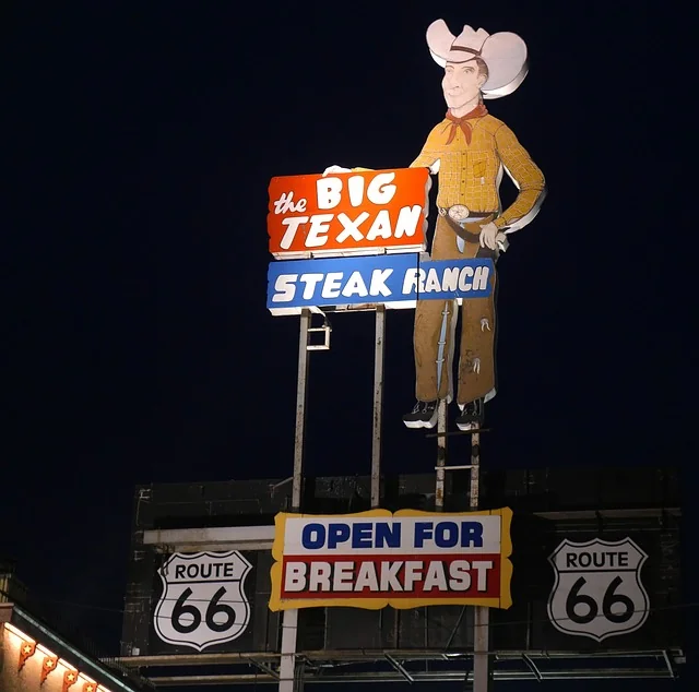
Cadillac Ranch near Amarillo, and the legendary
Big Texan Steak Ranch with its 72-oz steak challenge.
Arizona unfolds natural wonders: Petrified Forest National Park,
Meteor Crater, Winslow (homage to the Eagles' "Take It Easy"), Seligman
(capital of the Route 66 revival), and the ghost town of Oatman.
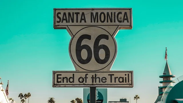
The triumphant arrival is at Santa Monica Pier, facing the Pacific,
where a commemorative plaque marks the symbolic terminus of the Mother Road.
Big Texan Steak Ranch, Amarillo (Texas): a Route 66 institution and the 72-oz steak challenge.Santa Monica Pier (California): symbolic terminus of Route 66, facing the Pacific Ocean.
Notable facts
10. Verified historical anecdotes
Eighteen short notes, each tied to an institutional or documented source.
Nov. 11, 1926
Born in the federal highway system
U.S. Route 66 was officially designated on November 11, 1926, among the first federal highways, numbered "66" to connect the Midwest to the Pacific.
Source: Federal Highway Administration, Historic Route 661938
First paved coast-to-coast highway
By 1938, Route 66 was fully paved, easing commercial traffic and westward migration during the Great Depression.
Source: National Park Service, Travel Route 661939
The "Mother Road" nickname
John Steinbeck dubbed Route 66 "the Mother Road" in The Grapes of Wrath, capturing farmers fleeing the Dust Bowl for California.
Source: John Steinbeck, The Grapes of Wrath (1939)1946
A song written on the road
Bobby Troup composed "(Get Your Kicks on) Route 66" during his own drive to California. The Nat King Cole Trio turned it into a standard that same year.
Source: Library of Congress, National Jukebox1956
The Interstate era begins
The Federal-Aid Highway Act of 1956 launched the federal interstate system. Route 66 would be bypassed segment by segment over the coming decades.
Source: Federal Highway Administration1960-1964
The "Route 66" TV show
The CBS series put two wanderers in a Corvette at the heart of American pop culture, though many episodes were filmed off the historic alignment.
Source: Library of Congress, Television CollectionJune 27, 1985
Removed from the federal system
AASHTO dropped Route 66 from the official U.S. Highway list. Federal signs came down, but local alignments remained on the ground.
Source: National Park Service, Route 66 Corridor1987
Angel Delgadillo, keeper of the road
Barber Angel Delgadillo founded the first major preservation association in Seligman, Arizona. His work revived tourism and later inspired Pixar.
Source: Historic Route 66 Association of Arizona1974
Cadillac Ranch
The Ant Farm art collective planted ten Cadillacs nose-down in the dirt near Amarillo. The installation became one of the most photographed stops on the road.
Source: National Park Service, Cadillac RanchKansas
The shortest of the eight states
Route 66 crosses Kansas for only about 13 miles (~21 km) between Galena and the Oklahoma border, the briefest stretch on the entire route.
Source: National Park Service, Kansas Route 66Will Rogers
The "Will Rogers Highway"
Route 66 was dedicated to humorist Will Rogers. A commemorative plaque near Santa Monica Pier still honors that official tribute.
Source: National Park Service, Route 662006
Inspiration for Pixar's "Cars"
For Cars, the Pixar team drove Route 66. Radiator Springs and its decline faithfully reflect towns bypassed by the Interstates.
Source: Pixar / National Park Service, Route 66 CorridorCatoosa OK
The Blue Whale
Hugh Davis built a concrete blue whale in 1972 as a birthday gift for his wife. It became a swim park, then a Route 66 icon drawing travelers for decades.
Source: National Park Service, Blue Whale of CatoosaSeligman AZ
Capital of the revival
Bypassed by I-40, Seligman came back to life through Historic Route 66 signage and retro businesses. Angel Delgadillo still runs his barbershop and gift store there.
Source: Historic Route 66 Association of ArizonaChicago IL
Two "start" signs
The symbolic starting point sits near the Art Institute of Chicago (Adams Street). Other commemorative markers exist around the area per local associations.
Source: Illinois Route 66 Scenic BywaySanta Monica CA
The friendly "real terminus" debate
Historically the route ended in Santa Monica. A plaque on the Pier and other markers (including on 7th Street) coexist, fueling a good-natured debate among enthusiasts.
Source: National Park Service, End of Route 661950-1960
The golden age of neon
Themed motels (Wigwam, Blue Swallow), diners, and neon signs turned the road into a gallery of Americana kitsch before the post-Interstate decline.
Source: Library of Congress, Route 66 Collection2026
Centennial and federal commission
Congress created a Route 66 Centennial Commission to coordinate celebrations, exhibitions, and heritage projects for the road's 100th anniversary.
Source: route66centennial.org
Collective memory
11. Cultural impact and revival
More than a highway, Route 66 became a symbol of freedom:
the open road, escape, and the search for a better life. Literature
(Steinbeck, Kerouac), music (Nat King Cole, Chuck Berry, Depeche Mode),
film (Easy Rider, Badlands, Cars), and television
etched its myth into the global imagination, far beyond American borders.
After decommissioning in 1985, enthusiasts worldwide helped bring it back.
Restored neon motels, dedicated museums (Clinton OK, Pontiac IL), festivals, and
classic car clubs testify to thriving nostalgia tourism. The NPS documents
the corridor as national cultural heritage.
Approaching the 2026 centennial, the Mother Road has never been
more alive: marked alignments, digital guides, state-by-state events, and
international visitors (including European and Francophone travelers) keep alive
the legend of a road that was, and remains, America's ribbon across the continent.
Frequently asked questions
12. FAQ
Where does Route 66 start and end?
Historically, Route 66 linked Chicago (Illinois) to Santa Monica (California). The symbolic start is near the Art Institute of Chicago; the official end is Santa Monica Pier.
How long is Route 66 in miles?
The historic alignment covers roughly 2,448 miles (about 3,940 km), depending on state alignments.
Which states does it cross?
Eight states, east to west: Illinois, Missouri, Kansas, Oklahoma, Texas, New Mexico, Arizona, and California.
Can you still drive it today?
Yes. Decommissioned in 1985, much remains drivable: the NPS estimates about 85% of the historic alignment is still accessible via Historic Route 66 sections.
When was it created and removed from the federal system?
Created November 11, 1926, fully paved by 1938, officially removed from the U.S. Highway System on June 27, 1985.
Why is it called the Mother Road?
John Steinbeck called it the Mother Road in The Grapes of Wrath (1939), describing Dust Bowl families heading to California.
What are must-see stops?
Gateway Arch (St. Louis), Cadillac Ranch (Amarillo), Big Texan Steak Ranch, Petrified Forest (Arizona), Seligman, Hackberry General Store, and Santa Monica Pier.
How many days should you allow for a road trip?
Allow at least 7 days for a quick overview, 14 for a balanced trip, or 21 to explore detours and museums without rushing.
Do you need a rental car?
A car (rental or your own) is essential. Bring valid U.S. auto insurance, offline maps, and motel reservations in peak season.
Where can you find official maps and guides?
The National Park Service (Travel Route 66), FHWA, Library of Congress, and route66centennial.org provide maps, alignments, and planning resources.
Transparency: France-USA-Net.Com is not the NPS, the FHWA, or an official state tourism office. This content is informational and draws on public sources. Alignments and road closures change; verify official references (NPS, state offices) before you leave.